At the source of the nightmare
Independent journalist describes the scene in the Gulf of Mexico where the Deepwater Horizon drilling platform exploded. Dahr's reports from Louisiana, along with photos by Erika Blumenfeld, can be found at Dahr Jamail's Dispatches Web site.
ACCORDING TO BP and the U.S. government, little or no oil is escaping into the Gulf of Mexico from BP's Macondo well--for the first time in three months. The new capping stack was deployed on July 11 from onboard the Transocean Discoverer Inspiration. With a new containment cap atop the damaged well, many are hopeful.
But all is not well, after all. National Incident Commander Thad Allen said that the pressure within the cap is not increasing, as was expected.
The idea is that the pressure (in pounds per square inch, or PSI) within the cap should balance out between 8-9,000 PSI, which would show that the well has maintained integrity. BP hoped to reach 9,000 PSI, but stated that well integrity would be maintained with 7,500-plus PSI. Unfortunately for BP, if the pressure tops out below that level, as it is now at 6,720 PSI, this could be an indication of a sub-sea leak somewhere deeper inside the well casing, meaning the well has failed.
One concern associated with this lower pressure is that it may indicate that the well has been breached, and that oil and gas are leaking out into the Gulf at other undetermined points.
Given BP's proven propensity toward lying, skeptics--who are consistently needed to keep BP's rhetoric in check--are also pointing toward other factors that could mean oil is continuing to spew into the Gulf near the well.
"With the pressure now virtually level at 6,700 [psi], it's at the lower end of the ambiguity range, so it seems there is a good chance there is leak-off," writes the Daily Hurricane. "That makes a lot of sense to me since there [are] 1,200 feet of open hole from the bottom of the 9 7/8 inch liner to TD at about 18,300 feet. That's not to mention possible casing damage up hole.
"Think of it like a garden hose with a nozzle on the end. As long as the nozzle is open, the hose looks fine. As soon as you close the nozzle, the hose will leak through any pinholes or around the faucet as pressure builds inside. In his statement late yesterday, Admiral Allen indicated they were probably going to go back to containment, which means they'll be flowing the well to the various ships they have on station."
Like virtually every other aspect of BP's oil catastrophe in the Gulf, we'll have to wait and see how bad this really is.
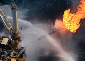
ON JULY 12, we took a flight out to what is referred to now as "the source": the former site of the Deepwater Horizon rig. It's taken me this long to be able to write about what we saw because it was, frankly, traumatizing.
Oil sheen and sub-surface plumes of oil were visible long before we arrived at the source, located approximately 45 miles off the southeast coast of Louisiana.
In what has been a consistently maddening theme of our trip, flying out to the source found us viewing countless oil platforms, and in some cases, drilling rigs, all of which comprised the oily backdrop of BP's disaster.
The stench of the oil began to infiltrate my nose and burn my eyes long before we arrived at the source. Black oil clouds lurked below choppy blue seas in every direction, as a virtual cityscape of ships and drill rigs loomed on the horizon. They appeared to rise out of the Gulf as we approached.
We were cleared to fly at 1,500 feet, well below the FAA mandated 3,000 feet. My stomach sank as we began to bank to our right, starting the first of countless clockwise circles around the warlike scene.
A giant flame--the burning off of methane and benzene--roared off the side of a rig, leaving a chemical gas floating lazily to the south as it rose. Cory, our young pilot, flew us directly through this cloud. The plane shuddered in the turbulence. I felt sick and dizzy after one breath, and with each future pass, I held my breath, all through the entirety of the southern portion of the circle, to avoid chemical exposure.
The scene felt like death--an epic example of manmade destruction, damage and mayhem let loose upon the earth. It is as unnatural a scene as one can imagine. That the Gulf, its marine life, ecosystems and all the life that depend upon it are not under constant assault from this catastrophe is unthinkable.
As our small plane perpetually banked to the right, Erika shot hundreds upon hundreds of photos of this terrible scene. While staring at the appalling scene scudding by below us, I scribbled notes like:
Death in the blue
Oil makes blue Gulf appear like cancer-ridden areas
Couldn't look more unnatural
Burning eyes
Trouble breathing
Gulf looks bruised
The thick, humid, chemical-laden air astounded me. I wondered about the health of the hundreds of people down in the ships, working around the clock to try to stop the volcano of oil.
AFTER WE'D taken as many photos as we could, our eyes sufficiently burning, we all agreed to head back towards the coast. The flight was long enough, hovering over countless wells and platforms, for me to ponder what our dependence on oil is costing the planet.
We diverted our journey to fly over the Chandeleur Islands to see yet more chaotic booming, oil-burnt marsh, sheen and threatened birds.
Adm. Thad Allen warned of too much optimism towards the cap. "It remains likely that we will return to the containment process using this new stacking cap connected to the risers to attempt to collect up to 80,000 barrels of oil per day until the relief well is completed," he said.
I find it interesting that he, BP and President Obama have all cited this capacity to collect up to 80,000 barrels of oil per day, despite the fact that the high-end government estimate of daily flow is 60,000 barrels a day.
Yet the disaster continues. So far, approximately 1.82 million gallons of chemical dispersant have been applied, 348 controlled oil burns have been conducted, and if daily flow estimates of 100,000 barrels per day, provided by independent scientists, are correct, 34 Exxon Valdezes worth of oil have already been injected into the Gulf of Mexico.
As of July 14, approximately 572 miles of Gulf Coast shoreline were oiled, a number that does not include cumulative impacts. While most of the oil remains submerged (for now), we already have vast areas of coastline oiled: 328 miles in Louisiana, 108 miles in Mississippi (nearly the state's entire coastline), 67 miles in Alabama and 69 miles in Florida.
I hope others are as enraged as I am by the ongoing ticker tape of BP's stock price in news reports about the disaster, like this one: "News of the development just before Wall Street's close lifted BP shares. They added $2.74, or 7.6 percent, to close at $38.92, still well below the $60.48 they fetched before the rig explosion."
Why should we give a damn about the value of BP's stock while their criminal negligence is annihilating the Gulf of Mexico?
While the cap-praising and BP stock-value glee continues, biologists recently reported the finding of at least another 300-400 oiled pelicans and hundreds of terns in the largest seabird nesting area along the Louisiana coast.
This finding underscores the fact that the official tallies of oiled wildlife significantly underestimate the broad scope of the destruction. So far, roughly 3,000 oiled birds have been collected across the Gulf, so this finding alone is a significant increase in percentage terms.
"This is not like Exxon Valdez, where you had tens of thousands of birds killed all at once," said Ken Rosenberg, director of conservation science at the Cornell Laboratory of Ornithology. "It's more insidious because it is literally happening in waves, and it's happening over and over again as the birds are moving around."
Louisiana's St. Bernard Parish government reported that there have been at least 31 oil sightings in parish waters and on shorelines in just 48 hours. More oil-soaked birds, both dead and alive, have been reported, and the oil continues to spread. Much of this is happening around the Chandeleur Islands, where we'd already logged the futile booming.
Already, scientists are reporting how BP's oil disaster is altering the food web in the Gulf. On July 14, the Associated Press reported:
Scientists are reporting early signs that the Gulf of Mexico oil spill is altering the marine food web by killing or tainting some creatures and spurring the growth of others more suited to a fouled environment. Near the spill site, researchers have documented a massive die-off of pyrosomes--cucumber-shaped, gelatinous organisms fed on by endangered sea turtles.
The scope and scale of this disaster is impossible to communicate. While flying in giant, arcing circles around the source, I saw nothing but oil in every direction. Jonathan Henderson works for the Gulf Restoration Network. While looking out at the literal sea of oil beneath us, he reminded us that, at the moment, 75,000 square miles of the Gulf are covered in oil.
First published at Dahr Jamail's Dispatches.